 |
| Missing Mountainside, Fell into Madison River Canyon, 8/17/59 |
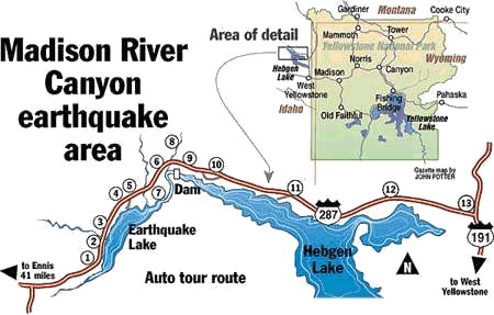
The epicenter, the point directly above where the quake occurred, was located near Duck Creek and the junction of Highways 287 and 191, eight miles north of West Yellowstone, Montana. But the quake was powerful enough to be felt in eight states, across 500,000 square miles.
 |
| Madison River Canyon before the earthquake. Note fault line that defines the zone where mountain cleaved off. |
The quake cleaved off 80 million tons of rock 16 miles downstream, literally shearing off the side of a mountain, which dropped at 100 miles per hour into the gorge containing the Madison River, and drove debris 300 feet up the other side. The landslide stopped the flow of the Madison River.
 |
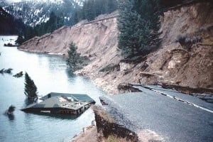
| Portions of Hwy 287 sheared off into Hebgen Lake |
An area of 38,000 acres, the [Earthquake Lake] reserve is testimony to one of the most violent earthquakes that shook the west on Aug. 17 1959 at 11:37 p.m. At that time, the Red Canyon fault and the Hebgen fault, both in the Madison River area, moved simultaneously and triggered an earthquake that measured 7.5 [since revised to 7.3] on the Richter scale. That earthquake forced a massive landslide that screamed down mountains and hills at about 100 miles per hour. Tons of rocks and earth crashed into Madison Canyon. The results were catastrophic. The force of the slide caused a flood and high winds swept a giant wave downstream. Five people died in the flood alone. The landslide killed another 28 people. It also dropped the north shore of Hebgen Lake 19 feet. Cabins on the shore washed into the water as huge waves crested over Hebgen Dam. Three sections of Highway 287 fell into the lake, the dam cracked in at least four places and hundreds of campers were trapped. The landslide eventually stopped, essentially damming the Madison River and creating Earthquake, or “Quake Lake,” a 190-foot deep, six mile long lake stocked with German and Brown Trout.Nineteen of the deaths resulted from the rock slide obliterating Rock Creek Public Campground at the bottom of the side. These victims remain entombed beneath 200 feet of rock. Upstream at the dammed Lake Hebegen, the drop along the fault line caused a seiche, sloshing a 5 to 10 swell of water over the dam built in 1915. The dam cracked in several places but survived sufficiently well to continue to hold back Hebgen Lake waters.
 |
| Memorial Boulder in Background, Thrown 300 feet up by Landslide, Earthquake Lake Visitors Center. Nineteen Victims are Entombed Below. |
The quake rocked the land so forcefully that travelers awoke to sheer terror. Along Hebgen Lake, shoreline cabins, lodges, and travel trailers were inundated with water.
Above the Madison River, boulders broke free from their moorings and came crashing through the night, flattening tents and automobiles. Throughout a 500-mile region, sand and bubbling water blasted from holes that erupted out of nowhere. Rivers ran red and brown.
In Yellowstone National Park, the quake brought on landslides. Streams moved out of their beds. Hot springs changed temperatures. Some 200 geysers began spewing forth hot water and mud.
With so many campers in the narrow Madison River Canyon, the massive landslide was destined to take away life. Rock Creek Campground, where 50 campers lay sleeping, was buried.
 |
| Cabin collapsed into Lake Hebegen |
Survivors said the noise from the slide was deafening. The wind it created tossed cars like matchboxes and ripped clothes off people who had no idea what had hit them.
“ I went to sleep about 9:30 p.m. and was awakened by the frenzied jiggling of the trailer....When I got outside, the trailer was in place, but the trees were whipping back and forth and the leaves were rustling as if moved by a strong wind—but there was no wind. I knew right then that it was an earthquake. I heard avalanches in the canyons behind me and could see huge clouds of dust billow out of the canyon mouths.” — Irving J. Witkind, geologist with the U.S. Geological Survey, who happened to be on-site, conducting studies.
As Earthquake Lake quickly began to fill, frightened campers fled for their lives. But their only escape route, Highway 287, had cracked into pieces. While the ground shuddered with aftershocks, about 250 campers were forced to climb in the darkness, away from the rising water.Surviving campers scrambled for high ground between the landslide and Hebgen Lake, now named Refugee Point.
The ridge provided protection during the night of Aug. 17, 1959, for many quake survivors. The next morning, FS smokejumpers parachuted to the point to set up rescue operations. Later that days, survivors were evacuated by helicopter.There was a massive relief effort.
Earthquake Lake in foreground, collapsed mountain in background.

As with most natural disasters, the hours following the earthquake were marked by chaos. Hundreds of people were trapped by the Madison River slide and damaged roads. Local, state, and federal authorities weren’t able to effectively organize until daylight, some five hours after the quake hit.
Mrs. Grace Miller, a 70-year-old widow and owner of the Hilgard Fishing Lodge on Hebgen Lake, awoke when the quake began. She ran out of her lodge door and jumped across a five-foot crevice just as her lodge dropped behind her into the lake. All of the buildings of the resort were destroyed by the quake.
A man trying to escape drove his family off a six-foot scarp along the red Canyon fault, overturning the car. Unbelievably, no one was seriously hurt.
Purley Bennett, his wife, and four children, were camped at the western edge of the canyon. The Bennetts were in their trailer and the children on the ground nearby. Awakened when the trailer started to shake, Purley Bennett left the trailer. Mrs. Bennett went out too, only to see her husband grab a tree, then disappear. Three of their four children were also gone.
A California couple perished when a huge boulder crashed through the Cliff Lake Campground, crushing them as they slept in their tent. Their three children, sleeping in a tent nearby, were unharmed.
At dawn, the U.S. Air Force sent four helicopters to do search and rescue. The Forest Service dropped in smoke jumpers who immediately began rescue operations. In all, 40 relief agencies were at work. By the close of the next day, 250 people had been rescued.Work began almost immediately to create a sustainable outlet for water accumulating behind the new earthen dam.
It was Earthquake Lake, however, that presented the greatest challenge. With the victims rescued, the Army Corps of Engineers began a race against time. Water rising behind the slide threatened to destroy the Hebgen Lake Dam, or worse, overtop the slide and flood downstream. Teams worked around the clock, building a spillway for the water.
When water finally flowed through the spillway on September 10, however, something was clearly amiss. The grade was too steep, and the rushing water quickly caused erosion. Work began anew, and on October 17, the new spillway at last carried the water from Earthquake Lake safely downstream, leaving the lake itself about 120 feet deep.
We visited Quake Lake this week where the power and fury of nature continue to be obvious and visible to the human eye. If you are visiting Yellowstone and entering or leaving from the West Yellowstone entrance, it is a quick and easy side trip. We recommend it to all.
 |
| Looking down Quake Lake, drowned trees still standing in foreground, notice high water mark from original lake level on opposite shore. |
 |
| More drowned trees in Earthquake Lake |
 |
| Drowned trees, opposite shore, Quake Lake. |
Wow!
ReplyDelete