 |
California Governor Jerry Brown during a message to the California
state legislature on Jan. 6, 1977, "We are going to have to learn to
share -- north and south -- all of us together." "It is the only way
we can solve this problem."
|
“And it never failed that during the dry years the people forgot about the rich years, and during the wet years they lost all memory of the dry years. It was always that way.”California is experiencing its most severe drought of my lifetime, though the drought is only modestly worse than the 1976-77 drought that intersected with my three year residence in California. When I moved to California in the fall of 1975 and first saw the indigenous flora it was brown, and it remained brown for the rest of the year and throughout 1976, and then through the summer and early fall of 1977. The dawning of the "Little Ice Age" was ascendant in the minds of many climatologists of the time, and the theory of global cooling was cited as possible cause.
There was a place on Stanford campus called Lake Laguanita. To my repeated observation it contained nary a liquid drop. So for two solid years that is what I thought California was -- dry and brown. And in a weird way it made sense that the good citizens of the Golden State elected young, austere Jerry Brown as governor. So now, almost forty years later California elected elderly, austere Jerry Brown. The citizenry are nothing if not consistent. They believe more in symbolism than solutions. Coincidental this is not.
 |
| Low water behind the Lake Shasta dam, March 2, 1977. |
There will always be drought somewhere -- most dramatically in semi-arid climates that depend on short seasonal surges of rain and snow to replenish water supplies. In these locales if they do not get their water in a three or four month window, there's no making it up later on.
Drought has myriad causes and periodicities, though that is not the way Dear President sees it. We have zero evidence that the man ever stuck his noggin inside a chemistry, physics, biology or meteorology lecture hall or worked at a bench in a scientific lab. He knows not the difference between the scientific and Socratic methods. He pontificates nevertheless.
[It] is undeniable .. that changing temperatures influence drought in at least three ways: Number one, more rain falls in extreme downpours -- so more water is lost to runoff than captured for use. Number two, more precipitation in the mountains falls as rain rather than snow -- so rivers run dry earlier in the year. Number three, soil and reservoirs lose more water to evaporation year-round.
What does all this mean? Unless and until we do more to combat carbon pollution that causes climate change, this trend is going to get worse. And the hard truth is even if we do take action on climate change, carbon pollution has built up in our atmosphere for decades. The planet is slowly going to keep warming for a long time to come. So we’re going to have to stop looking at these disasters as something to wait for; we've got to start looking at these disasters as something to prepare for, to anticipate, to start building new infrastructure, to start having new plans, to recalibrate the baseline that we're working off of.
And everybody, from farmers to industry to residential areas, to the north of California and the south of California and everyplace in between, as well as the entire Western region are going to have to start rethinking how we approach water for decades to come.From "Remarks by the President on the California Drought."
As for Dear President's asserted relationship between snow and temperature, overnight we got about six inches of snow here at Chez Gradyent, while temperatures ranged from 25 to 30 degrees. Let's say instead that the thermometer dropped to 5, 10 or 15 degrees. We likely would not have gotten more than one or two inches of the white stuff. The always frigid South Pole averages only eight inches of snow accumulation annually. That's not even a good snow day in the Sierra Nevada mountains along the eastern spine of California. Higher temperatures mean less snow? Colder temperatures means more snow? Forget about it. Duh, the colder it gets the drier it gets.
As for Dear President's claim about extreme downpours, a Californian he is not. We note that California is getting above normal rain so far this winter. Here is what the daily weather patterns looked like in Sacramento -- moderation on top of moderation. Obama lives in a factual wasteland.
2016 Temperature Precip. Accum.
Jan High Avg
1 48.6 °F 39.4 °F 0 in
2 50.5 °F 42.5 °F 0 in
3 56.7 °F 47.2 °F 0 in
4 55.2 °F 47.8 °F 0.21 in
5 54.5 °F 50.5 °F 1.48 in
6 52.2 °F 49.0 °F 0.53 in
7 53.2 °F 46.7 °F 0.04 in
8 53.1 °F 44.8 °F 0.02 in
9 54.1 °F 49.1 °F 0.09 in
10 57.2 °F 49.8 °F 0.13 in
11 59.4 °F 51.0 °F 0 in
12 59.5 °F 49.8 °F 0.01 in
13 60.4 °F 53.0 °F 0.47 in
14 52.7 °F 47.1 °F 0.09 in
15 55.6 °F 49.4 °F 0.14 in
It rained eleven out of first fifteen days of the year in Sacramento -- a total of 3.21 inches or an average of just over two tenths of an inch daily. Only once did it rain more than an inch in a single day -- that at 1.48 inches hardly qualifies as a gully washer.
Let's look at the daily January rainfall further north at Redding, California near Lake Shasta.
Daily Weather History
Jan. 2016 Precip. (in)
1 0.00
2 0.00
3 0.00
4 0.83
5 1.89
6 1.22
7 0.03
8 0.00
9 0.74
10 0.00
11 0.00
12 0.22
13 0.48
14 1.30
15 0.08
16 0.39
Redding has totalled 7.18 inches of rain, a little less than half an inch per day. Only the January 5th and 6th rainfall of just over 3 inches can be characterized as a major rain event, yet it is nothing compared to extreme events experienced elsewhere in the country that are buffeted by supercells or tropical systems.
Enough for Dear President's shamateurish predictions.
Let's look at data that the U.S. Federal Government publishes on the extent of drought. The "Drought Monitor" categorizes five levels of drought -- Abnormally Dry, Moderate Drought, Severe Drought, Extreme Drought and Exceptional Drought. Please excuse the adjective inflaton. That's from government bureaucracy -- they can't help themselves. It is important that public officials be of consequence.
Let's start with the three years back map which showed extreme and exceptional drought through much of the center of the country. Obama and company really liked talking about droughts and climate change back then.

On January 15, 2013, 71.15 percent of the country was in some sort of a drought condition or another.
Then fast forward to the present. Here is the most recent national Drought Monitor map.

Drought is non-existent in the areas that had severe and exceptional drought three years ago. The current concentration of exceptional and severe drought is centered on California. Only 29.54 percent of the U. S. landscape is now in drought, one of the smaller percentages in the 16 years of weekly observations included in the Drought Monitor. Things are improving.
To see just how quickly things can change when we were in Seattle this summer the news was afire with stories about drought and climate change. Rivers and reservoirs were drying up -- so we were told. One hundred percent of the state was in drought condition, all Severe and Extreme.

But look see now, a little over four months later. Only 39.55 percent of the state is in drought, and the least intense categories at that. If current weather patterns continue, the entire state may become drought free in upcoming weeks.

A primary driver of the 2015 drought was the absence of significant mountain snow packs left over from the 2014-15 winter season.
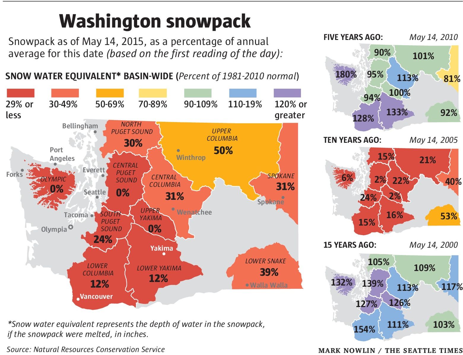
Large snow deficits persisted throughout the season causing ski resorts to shut down in late January and early February. By late spring snow water snowpack equivalents had plummeted to nothing and next to nothing in most of the state.
This year the story is quite different. Most of Washington state has significantly greater than normal snowpack.

Here are the current snow conditions at The Summit at Snoqualmie, 54 miles east of Seattle. Wow!
Today's snow conditions
The Summit at Snoqualmie: Open
Snow
Powder
Open trails
54/112
Open lifts
19/25
Base
| 84" |  | 36°F |
 |
Summit
| 84" |  | 29°F |
|


At sea level and in the valleys rain has been abundant.

Over the last ninety days, Seattle's rainfall is 8.8 inches, or about 50 percent high than normal.

Yakima's three-month rainfall is 2.3 inches, or about 60 percent greater than normal.
Here is the most recent California Drought Monitor map. One hundred percent of the state is in drought.

We will be watching Calfornia closely and reporting as the winter goes on. Relief is in the offing -- and not from the government.
No comments:
Post a Comment